

Some links on our site may earn us a commission at no extra cost to you. Learn more.
Foothills Parkway is a scenic park road along the western edge of Great Smoky Mountains National Park. The main stretch runs 33 continuous miles from Chilhowee to Wears Valley. A separate, shorter piece connects Cosby to I-40 on the far side of the park. Plan on ninety minutes for the western drive with stops, longer if you walk out to Look Rock Tower. It’s a natural add-on leg for our Smoky Mountains road trip itinerary if you’re stringing several stops into one loop.
I’ve driven Foothills Parkway more times than I can count. It’s usually my detour when Cades Cove is backed up with cars and I want mountains without the traffic. It almost never gets crowded, even in October. That alone makes the extra twenty minutes worth it. The overlooks are the real draw. Long, open views across ridge after ridge, instead of the tree-tunnel feeling you get on most Smokies roads.
Foothills Parkway West
The western section runs 33 continuous miles from Chilhowee, near the US 129 junction, to Wears Valley, a few minutes from Townsend. It’s built in two halves. Chilhowee to Walland covers 16.6 miles. Walland to Wears Valley covers roughly 14.75 more. Both halves are paved and two-lane, lined with pull-offs instead of shoulders. Plan to actually stop at the overlooks, not just slow down for a look.
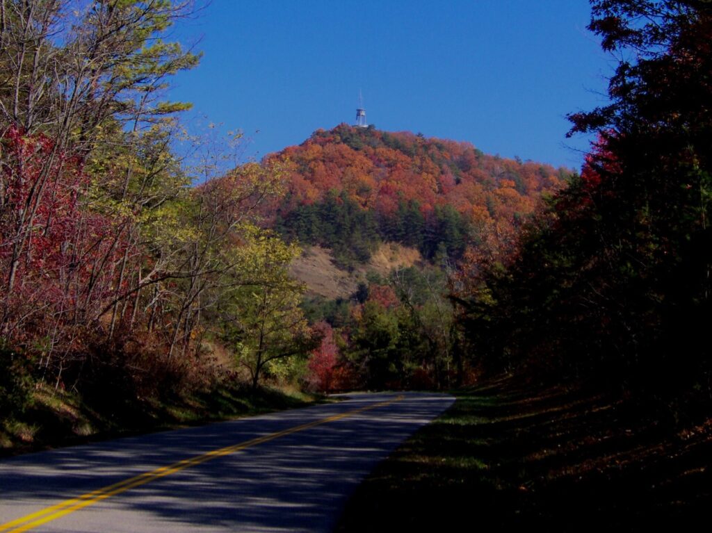
The Chilhowee end climbs onto the mountain fast, with the road curving along a ridge for most of its length. Just south of that junction on US 129 is the Tail of the Dragon, a motorcycle road famous for its dense run of curves — a very different kind of drive from the parkway’s easy pace. The Walland-to-Wears-Valley half feels different. It crosses valleys on tall viaducts strung between Grassy, Rocky and Davis Mountains. For a few minutes you’re driving above the treeline instead of through it.
Foothills Parkway East
The east side is a separate, shorter drive: 5.6 miles one-way between Cosby and I-40. It’s easy to miss, because it doesn’t connect to the west section at all. You’d have to drive around the entire park to link the two.
Four named overlooks break up the short drive: Cosby, Green Mountain, Allen Grove and Greasy Cove. Each one faces a different direction across the ridgelines. Think of it as a quick add-on if you’re already near Cosby Campground or heading toward Waterville. It isn’t a destination drive on its own, but it’s a nice way to stretch your legs between stops if you’re staying on the Tennessee side near Cosby or Gatlinburg rather than out west near Townsend.
Foothills Parkway Overlooks
Between the two sections there are more than twenty formal overlooks and pull-offs. Most are worth the thirty seconds it takes to stop, and a few are worth parking for longer. Here’s where the named stops sit, mile by mile, so you can decide which ones fit your schedule.
| Stop | Section | Approx. Mile | Notes |
|---|---|---|---|
| Look Rock Tower | West (Chilhowee–Walland) | Mile 7.1 | 0.8-mile paved trail to an observation deck |
| Look Rock Campground | West (Chilhowee–Walland) | Mile 7.5 | 68 sites, flush toilets |
| Capshaw Branch Overlook | West (Walland–Wears Valley) | Milepost 21 | One of ten stops on this half |
| Townsend Overlook | West (Walland–Wears Valley) | Milepost 25 | Views down toward Townsend |
| Caylor Gap | West (Walland–Wears Valley) | Milepost 26–27 | Wide panoramic stop |
| Cosby Overlook | East (Cosby–I-40) | Mile 1.4 | 1,811 ft, faces southwest |
| Green Mountain Overlook | East (Cosby–I-40) | Mile 2.2 | 2,136 ft, faces southeast |
| Allen Grove Overlook | East (Cosby–I-40) | Mile 3.6 | 1,948 ft, faces northwest |
| Greasy Cove Overlook | East (Cosby–I-40) | Mile 4.7 | 1,603 ft, faces northwest |
Look Rock Tower
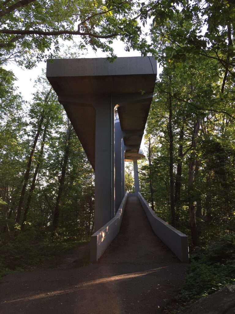
Look Rock Tower sits at mile 7.1 of the Chilhowee-to-Walland drive. It’s reached by a 0.8-mile round-trip paved trail. The grade is mild until the final ramp, which is genuinely steep. The tower is a concrete structure with a spiraling walkway, built as a fire lookout and air-quality station rather than for tourists. It works well for both jobs.
From the top you get a full 360-degree view. The main crest of the Smokies fills the view south. Chilhowee Lake and the foothills spread out to the west. On a clear day the haze thins out enough to pick out individual ridgelines, instead of one blue wall. Go in the last hour before sunset if you can. The crowd is thin and the light does the ridges a favor.
Look Rock Campground
Look Rock Campground sits right next to the tower trailhead, at mile 7.5. The park reopened it in 2022 after a nine-year closure. It has 68 sites. Ten of them offer electric and water hookups — the first hookup sites the park has ever built. The rest have access to flush toilets and potable water but no hookups of their own.
It typically runs May through October. Like every campground in the park, reservations go through Recreation.gov rather than a phone call or a drive-up. It sits on top of a mountain instead of down in a valley, so it’s noticeably cooler at night than Cades Cove or Elkmont. Pack another layer.
Foothills Parkway Missing Link
For decades, a 1.65-mile gap between Walland and Wears Valley kept the western section in two disconnected pieces. It was the “Missing Link,” the gap that made this the oldest unfinished highway project in Tennessee. The National Park Service opened that final stretch on November 10, 2018. Nine bridges strung across the steep terrain finally closed the gap.
The whole corridor was authorized back in 1944. Only a little over 22 of the planned 72 miles have ever been built, spread across three separate open segments. Funding gaps and difficult terrain stalled the rest. There’s no announced timeline for finishing it. The parkway will likely stay exactly this size — two disconnected drives — for the foreseeable future.
Do You Need a Parking Pass for Foothills Parkway?
Yes, the parking tag applies here. The park’s fee page lists the tag requirement as applying to any vehicle parked longer than fifteen minutes, anywhere inside the park. It isn’t location-specific. A Foothills Parkway overlook or the Look Rock Campground counts exactly the same as a spot at Cades Cove or Sugarlands.
Daily, weekly and annual tags run $5, $15 and $40. Most overlooks only need a two- or three-minute stop for photos. You can hit several without a tag at all. It’s the tower hike, or any campground stay, that pushes you past fifteen minutes.
Best Time to Drive Through the Smoky Mountains
Late October is the best window for Foothills Parkway specifically. The elevation gain means color shows up here before it peaks down in the valleys. Early morning is a close second choice, year-round. The haze that gives the Smokies their name is thinnest right after sunrise, before the day heats up and the ridgelines start to blur together.
Winter is the wild card. Foothills Parkway doesn’t have a fixed seasonal closure, the way Clingmans Dome Road does. But ice forms fast on the exposed ridge sections, especially near Look Rock where the road sits highest. The road can close with no warning on a cold morning, and it can reopen just as quickly once the sun gets to it. Check the park’s current conditions page before you commit to a drive between December and March, and have a backup plan like Cades Cove if the parkway is iced over.
What Is Foothills Parkway?
Quick answers to the questions we get asked most about this drive.
What is Foothills Parkway? It’s a scenic park road along the western boundary of Great Smoky Mountains National Park, built for the overlooks rather than as a through route. It exists in two separate, unconnected sections.
Is Foothills Parkway open? Both sections are open year-round, with no scheduled seasonal closure. Ice can shut the road temporarily in winter, so check the park’s road status page before a cold-weather trip.
How long is the Foothills Parkway? The western section covers 33 continuous miles, from Chilhowee to Wears Valley. The eastern section, between Cosby and I-40, is a separate 5.6-mile drive.
Do you need a parking pass for Foothills Parkway? Yes, if you’re stopped longer than fifteen minutes. The park’s parking tag applies here exactly as it does anywhere else inside the boundary.
Where does Foothills Parkway begin and end? The west section runs from Chilhowee, near US 129, to Wears Valley. The east section runs from Cosby to I-40, on the opposite side of the park.

Is the Foothills Parkway Worth It?
I’d put it on the itinerary, but not as a headline stop. If you’ve already done Cades Cove, Newfound Gap and Kuwohi, Foothills Parkway shows you the park from outside instead of from within it. It does that without a single traffic jam, which is worth something on a busy weekend. It’s a half-day add, not a full day, and it pairs naturally with Townsend or Wears Valley as a base rather than Gatlinburg. Bring a jacket even in fall — the overlooks sit exposed and the wind picks up fast once you step out of the car.
Skip it if you’re tight on time and haven’t done the essentials yet. Cades Cove and Newfound Gap Road earn the priority on a first trip. On a second or third visit, this is one of the best uses of a spare afternoon — especially if you want mountains without the crowds. Continuing into North Carolina afterward? The Blue Ridge Parkway between Asheville and Cherokee is the natural next scenic drive, with the same overlook-heavy pace on a much longer road.
Prices are approximate, current as of publication, and change frequently — confirm the latest price with the retailer before buying.
Published September 27, 2026.
Photo credits: (1) featured, A wide mountain overlook view along the… — Brian Stansberry, CC BY 3.0, via Wikimedia Commons; (2) A mountain view from an overlook near Look… — Brian Stansberry, CC BY 3.0, via Wikimedia Commons; (3) The concrete Look Rock Observation Tower… — Famartin, CC BY-SA 4.0, via Wikimedia Commons; (4) Layered mountain ridges seen from an… — Alex Sorokine, CC BY 3.0, via Wikimedia Commons.