

Some links on our site may earn us a commission at no extra cost to you. Learn more.
Waterfalls near Asheville cluster in three pockets: Pisgah National Forest, DuPont State Recreational Forest, and the Blue Ridge Parkway corridor. Pisgah sits to the southwest, DuPont is near Cedar Mountain, and the parkway runs northeast toward Linville. Some are roadside. Others take a real hike, with wet rock and steep drop-offs once you arrive. Most are free, though a few charge a small day-use fee. Nearly all of them took some kind of hit from Hurricane Helene in September 2024, so recovery status still varies fall to fall.
I’ve spent plenty of time chasing waterfalls through these mountains, and the split between drive-up falls and hike-in falls changes the whole day. A roadside fall like Looking Glass is done in fifteen minutes, no boots required. A hike-in fall is different. Wet rock the moment you get close. Spray drifting onto the trail. Then a “quick stop” eats an entire afternoon, once you count the drive, the walk in, and the time everyone spends standing at the base not wanting to leave. So bring shoes with real tread. The rocks here are slicker than they look, wet or dry, and a short list can turn into a full day faster than you’d plan for.
Quick facts
| Detail | What to know |
|---|---|
| Main clusters | Pisgah National Forest, DuPont State Forest, Blue Ridge Parkway |
| Agencies | U.S. Forest Service, NC Forest Service, National Park Service |
| Typical fee | Free; Whitewater Falls charges $3 per vehicle |
| Post-Helene status | Mixed — most trails open, some stairs still closed |
| Roadside options | Looking Glass Falls, Linville Falls overlooks |
| Best season | Spring for volume, fall for color |
| Swimming | Prohibited at most falls, per the agencies |
| Pets | Leashed dogs allowed on most trails |
Waterfalls Near Asheville
The table below lines up nine falls across the three clusters, using the figures each agency actually publishes. Where an agency doesn’t state a height or a trail length, that cell says so instead of guessing.
| Waterfall | Height | Hike to reach it | Fee | Managed by |
|---|---|---|---|---|
| Looking Glass Falls | Not stated by the Forest Service | Roadside; viewing deck and stairs to the creek | None | U.S. Forest Service, Pisgah Ranger District |
| Moore Cove Falls | Not stated by the Forest Service | 0.7 mile one way, easy | Not stated by the Forest Service | U.S. Forest Service, Pisgah Ranger District |
| Catawba Falls | Lower 205 ft, upper 80 ft | 3.5-mile loop, easy to intermediate | Not stated by the Forest Service | U.S. Forest Service, Grandfather Ranger District |
| Triple Falls | Not stated by the NC Forest Service | Under 0.5 mile, foot traffic only | None | NC Forest Service |
| High Falls | Not stated by the NC Forest Service | Under 0.5 mile, foot traffic only | None | NC Forest Service |
| Hooker Falls | Not stated by the NC Forest Service | Under 0.5 mile, foot traffic only | None | NC Forest Service |
| Whitewater Falls | 411 ft (Upper, NC side) | Short paved overlook trail | $3 per vehicle per day, or $15 annual pass | U.S. Forest Service, Nantahala Ranger District |
| Crabtree Falls | 60 ft | 3-mile loop, moderately strenuous | None | National Park Service, Blue Ridge Parkway |
| Linville Falls | Not stated by the National Park Service | 1.6-mile round trip (Erwins View Trail) or 1.4-mile round trip (Linville Gorge Trail) | None | National Park Service, Blue Ridge Parkway |
Best Waterfalls Near Asheville
These three sit in Pisgah National Forest. They cover the range from no hike at all to a real loop with stairs.
Looking Glass Falls
Looking Glass Falls sits directly off Highway 276, and that’s the whole appeal. There’s no real trail, just a viewing deck at road level and a set of stairs down to the creek. The Forest Service also charges no fee here. It lists the site open daily, 9 a.m. to 5 p.m., from April through mid-November, with shorter weekday hours the rest of the year. Parking is limited along the highway shoulder, so arrive early on weekends. No restrooms or picnic tables are on site, and no lifeguard is on duty.
Moore Cove Falls
Moore Cove Falls, reached by Moore Cove Trail #318, is a 0.7-mile walk one way to the base. The Forest Service rates it easy. It’s a gentler outing than most on this list, and the trail crosses a footbridge before ending at the falls. Spring also brings wildflowers along the route, and the Forest Service marks mid-April through mid-May as the best stretch for both. Even so, no fee or closure is currently listed for the trail.
Catawba Falls
Catawba Falls, in the Grandfather Ranger District of Pisgah National Forest, reopened as a 3.5-mile loop after a two-year rebuild. That project added nearly 600 stairs, three overlooks and a 60-foot observation tower near the upper falls. Per the Forest Service’s own recreation page, the lower falls drop 205 feet and the upper falls another 80 feet. The lower stretch is an easy walk. The stairs above it, though, push the upper route into intermediate territory. As of September 2026, per the Forest Service, the full loop is open. Still, the upper viewing platform and the Wildflower Trail remain closed while Hurricane Helene repairs continue.

DuPont State Forest Waterfalls
DuPont State Recreational Forest, near Cedar Mountain, packs three named falls onto one short trail complex. The forest is open 5 a.m. to 10 p.m. daily, per the NC Forest Service, with no entry fee and free parking at every lot. So arrive before 9 a.m. or after 4 p.m. for an easier time finding a spot, especially in July, August and October. Climbing, jumping or sliding on any of the waterfalls is against forest rules, and swimming above the falls is prohibited too.
Triple Falls DuPont
Triple Falls Trail reopened to the public on May 21, 2025, after Hurricane Helene damage, per the NC Forest Service. It’s a less-than-half-mile, foot-traffic-only route. From one trailhead, it reaches Hooker Falls, Triple Falls and High Falls. The agency notes more than 700,000 people hike it every year. The stairs alongside Triple Falls itself are still closed this season, since floodwater partially washed them away; the remaining structure is fenced off pending repair or replacement.
High Falls DuPont
High Falls sits on the same short trail complex as Triple Falls and Hooker Falls. The NC Forest Service’s current closures page notes the High Falls visitor center had a brief closure for roof work this year. Even so, the parking area and trails stayed open throughout, and no height or trail-length figure for High Falls specifically is published by the state agency.
Hooker Falls Trail
Hooker Falls rounds out the trio, reached from the same trailhead as the other two. It’s one of three DuPont trails closed to bikes and horses, reserved for foot traffic, per the NC Forest Service’s own trail rules. As with High Falls and Triple Falls, though, no official height or length figure is published here.
Whitewater Falls NC
Whitewater Falls, in Nantahala National Forest near the South Carolina line, is billed by the Forest Service as the highest waterfall east of the Rockies. Upper Whitewater Falls drops 411 feet on the North Carolina side. A second drop, Lower Whitewater Falls, continues roughly another 400 feet across the state line in South Carolina. A short, paved overlook trail reaches the main viewpoint, though the Forest Service doesn’t publish its length. Admission runs $3 per vehicle per day, or $15 for an annual pass, purchased through recreation.gov. Hours are dawn to dusk, and the site is currently listed open. Even so, visit mornings or evenings if you can, since the Forest Service specifically flags heavy midday and holiday crowds here.
Crabtree Falls Near Asheville
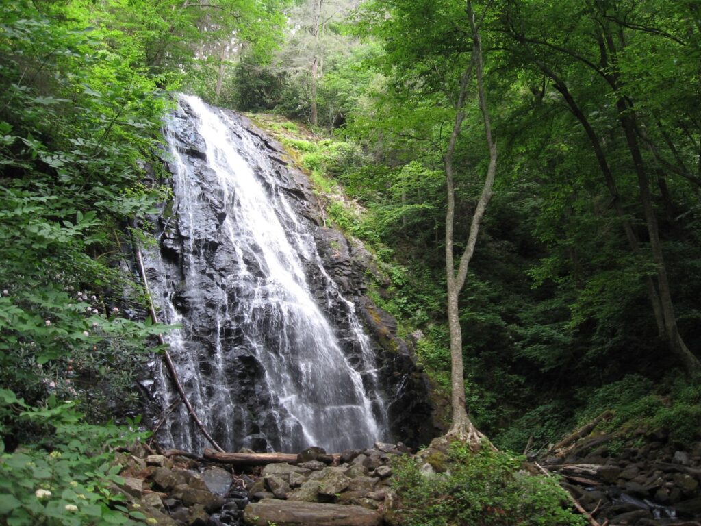
Crabtree Falls sits at Milepost 339.5 on the Blue Ridge Parkway. Like the rest of the parkway, there’s no entrance fee. The falls drop over what the Park Service describes as a 60-foot rock cliff. Reaching the base means a 3-mile loop trail, rated moderately strenuous, with a steep incline and rocky footing, so plan on 1.5 to 2.5 hours. A 92-site campground and picnic area also operate seasonally nearby. Check the parkway’s own road-status page before a fall or winter visit, since sections close for weather independent of any single trail.
Linville Falls
Linville Falls, at Milepost 316, is one of the more photographed stops on the whole parkway. It’s easy to see why once the gorge opens up below you. The National Park Service doesn’t publish a height figure for the falls, but three trails reach different views of it. Erwins View Trail is a 1.6-mile round trip, rated moderate, with four separate overlooks. Linville Gorge Trail is steeper, a 1.4-mile round trip down to the base of the lower falls. Plunge Basin Trail is shorter still, a 1-mile round trip to a view of the lower falls and the rock formations called the Chimneys.
As of September 2026, per the National Park Service, some trails in the area remain closed from Hurricane Helene. So check current conditions before you commit to a specific route. Swimming in the river and climbing on the rocks are also both against park rules, and the drop from several viewpoints here is real.

Waterfalls Near Asheville NC
A few more falls in this corridor are worth knowing about, even if they get the fuller writeup elsewhere on this site. Sliding Rock, also in Pisgah National Forest, is the one waterfall here you’re meant to ride rather than photograph, with lifeguards on duty during the summer season. Hickory Nut Falls, inside Chimney Rock State Park in Hickory Nut Gorge, reaches its base via a 1.4-mile round-trip trail rated moderate, per the park’s own trail page. It’s also the waterfall used for the climax of The Last of the Mohicans.
Near the South Carolina line, the Pretty Place chapel and Rainbow Falls hike pairs a mountaintop chapel overlook with a waterfall hike on the same trip. None of these three are officially linked to the falls above. Still, they sit close enough to fold into the same waterfall-focused trip through the mountains, alongside an overnight stop like Oconee State Park if you’re making a weekend of it.
Frequently asked questions about waterfalls near Asheville
Is Looking Glass Falls open?
Yes. The Forest Service lists it open daily, 9 a.m. to 5 p.m., from April through mid-November, with shorter hours the rest of the year. Also, no fee is charged, and no closure is currently listed for the site.
What are the roadside waterfalls near Asheville?
For an easy outing, Looking Glass Falls needs no hike at all. Moore Cove Falls is a flat 0.7-mile walk each way. Catawba Falls, at 3.5 miles round trip with nearly 600 stairs, is the longer option of the three, per the Forest Service.
How tall is Whitewater Falls?
Upper Whitewater Falls drops 411 feet on the North Carolina side, per the Forest Service, which calls it the highest waterfall east of the Rockies. A second drop, Lower Whitewater Falls, continues into South Carolina.
Is Crabtree Falls open?
The National Park Service doesn’t list a specific closure for the Crabtree Falls trail itself. Even so, check the parkway’s road-status page before visiting, since sections of the Blue Ridge Parkway close independently for weather and maintenance.
Is Linville Falls open?
The main falls and its overlook trails are open, but the National Park Service notes some trails in the area remain closed from Hurricane Helene, as of September 2026. So confirm current trail status before you go.
What are the easiest waterfalls near Asheville?
Looking Glass Falls needs no hike at all, since it sits right off the highway. Moore Cove Falls is the next easiest, a flat 0.7-mile walk each way rated easy by the Forest Service. Triple Falls, High Falls and Hooker Falls, in DuPont State Recreational Forest, are also short and mostly level, though the closed stairs at Triple Falls change that route for now.
Prices are approximate, current as of publication, and change frequently — confirm the latest price with the park, operator or provider before you go.
Published September 24, 2026.
Photo credits: (1) featured, Ramsey Cascades, the tallest waterfall in… — National Park Service, U.S. Government work, public domain, via Wikimedia Commons.