

Some links on our site may earn us a commission at no extra cost to you. Learn more.
A Big Sur itinerary works as one long day from Carmel to San Simeon, or as two days with a night in the middle. The one-day version covers Point Lobos, Bixby Bridge, McWay Falls and the elephant seals. The two-day version adds Pfeiffer Beach and a Hearst Castle tour, and it feels far less rushed.
Before either plan, check whether Highway 1 is open. Slides, storms and wildfires close this road with little warning, and this year the Timber Fire closed part of it.
We have done long coastal drives with nieces and nephews along, and the lesson carries over to this one. Fill the tank and pack lunch before the first curve. I would treat Big Sur as a driving day with stops, not a day of hikes, because the road itself is the main event and it drives longer than it looks on a map.
Big Sur road conditions
Highway 1 through Big Sur can stay shut for a long time, and it did this year. Caltrans District 5 announced in a news release dated August 11, 2026 that Highway 1 was closed from 2 miles north of Julia Pfeiffer Burns State Park (Post Mile 37.5) to Fernwood (Post Mile 47) to support Timber Fire operations. It gave no reopening date and pointed drivers to US 101.
Treat that release as history, not as today’s status. The live source is Caltrans QuickMap, and Caltrans lists a road information line at 1-800-427-7623. I would open QuickMap the night before and again at breakfast, and I would not leave Carmel until it shows the road clear all the way to San Simeon. On October 4 its road-conditions page listed no Highway 1 closure in Big Sur. It did list one-way traffic control around the clock at Rocky Creek Bridge, south of Monterey, through November 30. Caltrans also has one-way signals at Point Sur and Mud Creek, so allow extra time.
The park pages tell the same story from the other side. In early October 2026 the Pfeiffer Big Sur State Park page listed the park as closed until further notice due to the Timber and Plaskett fires. All backcountry trails east of Highway 1 were closed indefinitely. The Julia Pfeiffer Burns page listed its day-use areas, restrooms and Partington Cove trail as open. Check both pages before you go.
A closure in the middle splits Big Sur into a northern half and a southern half with no road between them. If that happens, do one half and come back another day. Everything below assumes the road is open on your date.
Best stops in Big Sur
The stops run from north to south. The table gives the fee, the time to budget and the one fact that trips people up.
| Stop | Fee and parking | Time to budget | Notes |
|---|---|---|---|
| Point Lobos State Natural Reserve | $10 per vehicle | 1.5 to 2 hours | Open 8 a.m. to 7 p.m., last entry 6:30 p.m.; no dogs |
| Bixby Bridge | No fee; roadside pullouts | 20 to 30 minutes | Park fully off the pavement |
| Pfeiffer Beach | $15 per car; 65 spaces | 1 to 1.5 hours | Single-lane road; lot often full on weekends |
| Pfeiffer Big Sur State Park | $10 per vehicle | 1 hour | Closed by the Timber Fire in early October 2026; check status |
| McWay Falls (Julia Pfeiffer Burns) | $10 per vehicle | 45 minutes | Overlook only; no beach access |
| Piedras Blancas elephant seals | Free; free parking | 30 to 45 minutes | Sunrise to sunset; stay 50 to 100 feet back |
| Hearst Castle | $35 adult, $18 ages 5 to 12 (Grand Rooms tour) | About half a day | Tours usually start at 9 a.m. |
Point Lobos State Natural Reserve
Start here, and start early. The reserve opens at 8 a.m., the lot fills as the morning goes on, and the light off the water is at its best before the crowds arrive. The state parks page lists the entry fee at $10 per vehicle and says no one is admitted after 6:30 p.m.
The reserve is small enough to walk in a morning. The Cypress Grove Trail and the paths around Sea Lion Point are the classics, with wind-bent trees over rocky coves and kelp beds where sea otters and harbor seals show up. Dogs are not allowed anywhere inside, and they cannot be left in a parked car either.

Bixby Bridge
Bixby Bridge is the postcard stop, a single concrete arch crossing Bixby Creek about a dozen miles south of Carmel. There is no fee, only pullouts on the north side where everyone parks for the same photo. Pull completely off the road, because photographers wander into traffic on a road with almost no shoulder.
Garrapata State Park sits between Carmel and the bridge and works as a second pullout. The park’s page lists its hours as 8 a.m. to sunset. It also posts trail closures, so check it before hiking the Rocky Ridge Trail.
McWay Falls
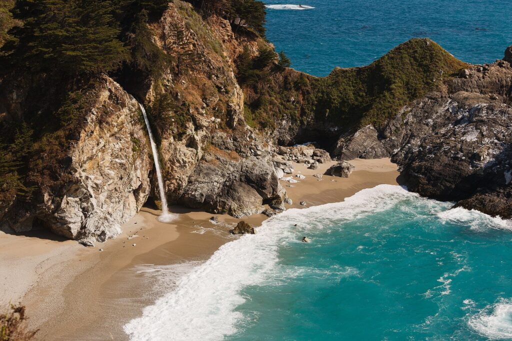
McWay Falls is an 80-foot waterfall that drops straight onto a small beach in a cove, and it is the reason Highway 1 traffic bunches up at Julia Pfeiffer Burns State Park. The overlook is a short walk from the lot, so it fits easily into a tight day. The park charges $10 per vehicle for day use, and the state parks page says one receipt covers other California state parks until closing on the same day.
You look at it from above and nothing more. The park page is blunt that there is no beach or ocean access at McWay Falls, and that cliff areas beyond the fences are off limits. Stay behind the fences.
Pfeiffer Beach Big Sur
Pfeiffer Beach is the one stop that takes real planning. The Forest Service puts the turn between the Big Sur Ranger Station and the post office, notes it is easy to miss, and describes a single-lane access road of about 2.2 miles. The lot holds 65 vehicles and is usually full on summer and holiday weekends, and the Forest Service lists the day-use fee at $15.
Parking along the road is not allowed, and a forest order bars anyone from being on Sycamore Canyon Road except inside a motor vehicle. Staff will turn you around when the lot is full. The beach itself is wide, with big sea stacks and an arch the afternoon sun pours through, and the waves are heavy enough that you should stay out of the water.

Big Sur restaurants
Food is the thing to plan. The village has a handful of restaurants and cafes, and a couple of them sit on cliffs where the view is part of what you pay for. Seats fill on weekends, and nothing replaces a packed lunch if the schedule slips.
I would eat a big breakfast in Carmel or Monterey and buy sandwiches there. Then a sit-down meal in Big Sur becomes a bonus instead of the plan.
Piedras Blancas elephant seals
The elephant seal viewing area sits 90 miles south of Monterey and 4 miles north of Hearst Castle. Friends of the Elephant Seal says it is free and open every day from sunrise to sunset, with docents on hand from 10 a.m. to 4 p.m. Parking is free and no reservation is needed.
Seals are on the beach all year, but December to March is the popular stretch, and most births have happened by late January. Expect a beach full of seals asleep in heaps, with the occasional fight breaking out. Federal guidance is to stay 50 to 100 feet back, and if a seal is looking at you, you are too close.

Hearst Castle tours
Hearst Castle is the southern bookend and the one stop that needs a ticket. The castle’s ticket page lists the Grand Rooms tour at $35 for adults and $18 for ages 5 to 12, with a $5.50 non-refundable registration fee included. Tours usually depart at 9 a.m., and you are asked to arrive 15 to 20 minutes early.
Book from home, since cell service on this coast cannot be trusted. Last tour times change by season, so check the day you plan to go.
Big Sur one day itinerary
One day from Carmel to San Simeon works if you start at the Point Lobos gate and accept that you will skip the castle. The times below are my plan, not posted schedules, and they leave room for slow traffic.
- 8:00 a.m. Point Lobos when the gate opens. Walk Cypress Grove and Sea Lion Point and leave by 9:45.
- 10:00 a.m. Garrapata and Bixby Bridge pullouts, about 30 minutes in total.
- 11:00 a.m. Pfeiffer Beach, if the Forest Service lot has space. Budget an hour with the road.
- 12:15 p.m. Lunch from your cooler, or a village meal if you planned one.
- 1:15 p.m. McWay Falls overlook, then fuel up if the tank is under half.
- 3:30 p.m. Piedras Blancas elephant seals, while docents are still on the beach.
That is a long day behind the wheel. Skip Pfeiffer Beach if the lot is full or the morning runs late, and nothing else changes.
Big Sur 2 day itinerary
Two days turns the same route into a trip. The best split puts the north and the middle on day one and the south on day two. Highway 1 lodging books out far ahead and costs more than inland rooms, so reserve before you commit to a date.
Day one: Point Lobos at 8 a.m., Bixby Bridge, Pfeiffer Beach, a long lunch, then McWay Falls. If Pfeiffer Big Sur State Park is open on your date, add an hour there. If it is closed, Andrew Molera State Park to the north is the stand-in I would use. Its day-use area was listed open in early October 2026, so check it too. Sleep in Big Sur, or push on to Cambria or San Simeon if the road is clear and you want a shorter second day.
Day two: Drive south in the morning light. Stop at the elephant seals, then take a Hearst Castle tour in the slot that follows. That order leaves the afternoon free for the drive home or on toward the Central Coast.
For the longer coast-wide trip that ties this stretch to Los Angeles and beyond, see our Pacific Coast Highway road trip itinerary. For budgeting gas, lodging and food across a trip like this, our road trip cost guide has the framework.
How long does it take to drive Big Sur?
Plan on about three hours of pure driving from Carmel to San Simeon, and more once you stop. The road is two lanes with long curves, a few places to pass, and a steady line of cars slowing for the same views. Use the turnouts to let people by, because tailgating on this road gets nobody there faster.
Gas is scarce and expensive, so fill up in Carmel or Monterey. Cell service is thin, too, and the state parks page for the Big Sur parks says it is extremely limited. Download your maps and tickets before you leave, and keep water and a layer in the car, as our road trip packing list suggests.
The best light is in the morning. Fog often sits on the coast and can lift by late morning, so a plan with the viewpoints in the afternoon beats one that spends the clear hours at a restaurant.
Best time to visit Big Sur
Spring and fall are the comfortable seasons, though wildfire can close the road in late summer and fall, as it did in August this year. Winter storms cause slides, and slides close the road. December to March is also the popular season for the elephant seals, and it brings wind and storms to the coast.
Summer and holiday weekends are the crowded ones. The Forest Service says the Pfeiffer Beach lot is usually full then, and the pullouts at Bixby and McWay fill fast. I would go midweek and start before 8 a.m.
Big Sur facts
Is Big Sur worth the drive?
Yes, if you like coastal scenery and do not mind a slow road. The payoff is the stretch between Bixby Bridge and McWay Falls, where cliffs drop straight to the water. If the road is closed or you are short on time, a half day at Point Lobos and Carmel is a fair substitute.
How long do you need in Big Sur?
One long day covers the main stops, and two days lets you add Pfeiffer Beach and a Hearst Castle tour. A day is mostly driving, so budget about three hours behind the wheel before any stops.
Is there cell service in Big Sur?
Barely. California State Parks calls cell service in the Big Sur parks extremely limited, so download maps and tickets before you leave and tell someone your route.
Are there gas stations in Big Sur?
Yes, but few, and the prices are high. Fill the tank in Carmel or Monterey and again in the south if the gauge is under half.
Prices are approximate, current as of publication, and change frequently — confirm the latest price with the retailer before buying.
Published October 21, 2026.
Photo credits: (1) featured, Bixby Creek Bridge arching across a canyon… — Diliff, CC BY-SA 3.0, via Wikimedia Commons; (2) Cypress Grove Trail at Point Lobos looking… — NOAA, U.S. Government work, public domain, via Wikimedia Commons; (3) McWay Falls dropping onto the beach in… — King of Hearts, CC BY-SA 3.0, via Wikimedia Commons; (4) Sea arch in the rock formations at Pfeiffer… — JERRYE AND ROY KLOTZ MD, CC BY-SA 3.0, via Wikimedia Commons; (5) Elephant seals resting on the sand at the… — Tuxyso, CC BY-SA 3.0, via Wikimedia Commons.