

Some links on our site may earn us a commission at no extra cost to you. Learn more.
Theodore Roosevelt National Park is North Dakota’s badlands park, with a South Unit at Medora and a North Unit about 50 miles off I-94. You can see the best of it in one or two days. Spend day one on the South Unit’s 36-mile paved loop, the prairie dog towns and a few short trails. Add a second day for the North Unit drive and River Bend Overlook.
Summers on a Midwest farm taught me to read a big sky, and the northern plains reward that habit. I would drive the loop at dusk, when the animals are out. The Midwest’s open-sky roads have their own pace, and here a bison on the shoulder is a reason to stop, not to honk. We have done national-park drives with nieces and nephews along. The lessons carry over: fill the tank first, carry water, and keep binoculars on the front seat.
Theodore Roosevelt National Park South Unit
The South Unit is the one most people mean when they say the park. It sits at Medora. The visitor center there shows a 17-minute film, and the museum and Maltese Cross Cabin open during center hours.
The Scenic Loop Drive is a 36-mile, two-way paved loop, and the park says to plan at least two hours. Treat that as a floor. You will stop for horses, pull off for the buttes and wait while a bison decides the road is his.

The loop is whole again after years of damage. The park’s November 25, 2025 release says the rebuilt section reopened. It runs from the East River Road intersection to the Old East Entrance Station pull-off. The closure began with rain damage and slides in 2019.
The park’s conditions page carries alerts and closures. Winter is the catch. The hours page says parts of the South Unit loop and the North Unit road may close in winter because of snow and ice. Look at the conditions page again the week you go.
Theodore Roosevelt National Park North Unit
The North Unit is quieter and farther from the interstate. It sits about 15 miles north of Watford City, a 50-mile drive from I-94. That makes it a deliberate detour, not a quick stop.
The scenic drive runs 14 miles each way to Oxbow Overlook, 28 miles round trip. Plan at least an hour and 15 minutes, the park says. The road is almost entirely paved with one stretch of gravel, and it is open to RVs and cyclists. A temporary building serves as the visitor center, so ask the rangers there about conditions.

River Bend Overlook is the stop that earns the detour, with the Little Missouri River curling through the bottomland below. Bison show up along the road through the day, and mule deer come out near dawn and dusk. Bighorn sheep sit on the cliff edges, and the prairie dogs here take a hike to reach.
One planning trap is the clock. The North Unit runs on Central time and the South Unit on Mountain time. A day that crosses between them gains or loses an hour.
Theodore Roosevelt National Park itinerary
Pick the plan by the time you have. Half a day is enough for the South Unit loop if you skip the side trails. A full day adds the short hikes and a meal in Medora. Two days add the North Unit.
Theodore Roosevelt National Park one day
I would start at the South Unit visitor center in Medora and pick up the latest road notes. Then I would drive the loop with a stop at Wind Canyon for the river view.
Coal Vein Trail fits the middle of the day. The three prairie dog towns reward a slow pass in the afternoon. I would eat in Medora, then head back out for the last hour of light. Dusk is when mule deer, coyotes and badgers move. It is the best reason to stay after the day-trippers leave.

2 days in Theodore Roosevelt National Park
Day two belongs to the North Unit. I would drive to Oxbow Overlook early and stop at River Bend on the way back. Then I would walk the 1.5-mile Caprock Coulee nature trail. That fills the morning, and the afternoon is free for the drive out.
Elkhorn Ranch Unit is optional and remote. The park says the last three miles sometimes need four-wheel drive or a high-clearance vehicle. That is most likely in winter or after rain. A 0.7-mile mowed path leads from the parking area to the foundation stones of Roosevelt’s cabin. There is no cell signal.
If the trip continues toward South Dakota, our Black Hills road trip picks up the next leg. For the full cost of a drive like that, see our national park road trip cost guide.
Theodore Roosevelt National Park hiking
Most of the best walks here are short, and the park rates them easy to moderate. Distances below are as the park lists them. Wind Canyon climbs to what the park calls the best view of the Little Missouri River in the South Unit.
| Stop or trail | Unit | Distance as listed | What you see |
|---|---|---|---|
| South Unit Scenic Loop Drive | South | 36-mile loop, at least 2 hours | Buttes, prairie dog towns, horses, bison |
| North Unit Scenic Drive | North | 14 miles each way, 28 round trip, at least 1 hour 15 minutes | River Bend and Oxbow overlooks |
| Wind Canyon Trail | South | 0.4 mile | Wind-carved canyon, river view |
| Coal Vein Trail | South | 0.6 mile inner loop, 0.8 mile outer | Badlands geology, old coal seam |
| Painted Canyon Nature Trail | South, off I-94 | 0.9 mile | Canyon rim and a walk down into it |
| Caprock Coulee | North | 1.5 miles nature trail, 4.3 miles full | Dry washes and badlands habitats |
| Petrified Forest Loop | South | 10.3 miles | Petrified wood in remote badlands |
| Elkhorn Ranch Unit | Separate unit | 0.7-mile path from parking | Foundation stones of the cabin site |
In early October 2026 the South Unit page still listed the 0.6-mile Ridgeline Nature Trail as inaccessible because of a road collapse, though the main trail page did not mention it. The trail has stairs and moderate to steep grades. Ask at the visitor center before you plan around it.
For something longer, the Maah Daah Hey Trail runs 96 miles across the grassland and links all three park units. Hikers yield to horseback riders.
Theodore Roosevelt National Park wildlife
Bison, wild horses, prairie dogs, mule deer, pronghorn and elk all live here. The rule on the park’s wildlife page is to stay at least 25 yards from every animal. Keep pets in the vehicle, and skip wildlife calls and spotlights because both are illegal.
Bison cross park roads in both units. Elk favor the Buck Hill area and the grassland you can see from I-94. Longhorns graze near mile marker two in the North Unit. The South Unit has three large prairie dog towns, and the North Unit has one near Caprock Coulee.
Timing matters more than luck. Mule deer move from dusk to dawn. Coyotes work the prairie dog towns in the twilight, and badgers show near the towns at dawn or dusk. Drive slowly, because animals cross without warning.
Theodore Roosevelt National Park wild horses
The wild horses are feral. You can find them in the South Unit, along the Scenic Loop Drive and from I-94. They look calm but are not tame, so the 25-yard rule applies to them too. The park says it is working to keep the herd healthy and genetically viable.
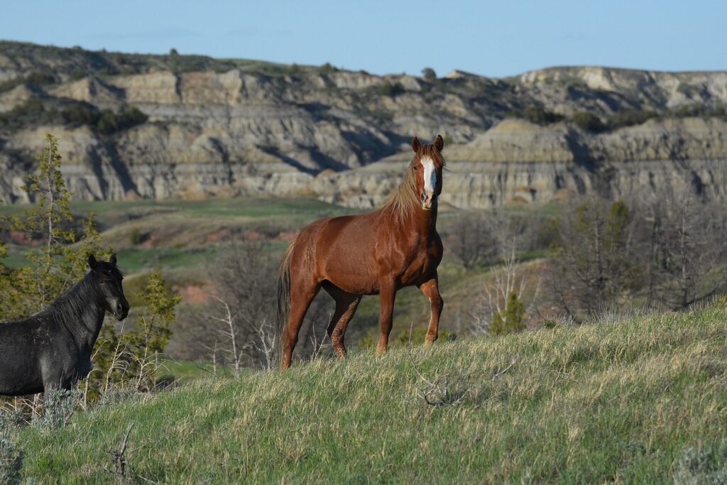
I would keep a long lens handy and let the horses cross in their own time. Pull off with room to spare, turn off the engine and wait.
Painted Canyon Visitor Center
Painted Canyon is the quickest stop. The visitor center sits on I-94, 7 miles east of the scenic drive entrance. You can see the canyon without committing to the loop. It works as a break on a long drive across the state.
The 0.9-mile Painted Canyon Nature Trail drops into the canyon from the rim. Call the park at 701-623-4466 for the center’s hours before you plan around it.
Medora North Dakota
Medora is the base, and it sits at the South Unit entrance. For anything Medora lacks, the park lists Belfield 15 miles east, Beach 25 miles west and Dickinson 35 miles east.
The town leans seasonal. In early October 2026, medora.com listed the Medora Musical as a summer show without dates for the next season. It also listed a 2026 fall concert run at the Old Town Hall Theater from October 21 to November 1. The same page lists year-round lodging, dining and gift shops. The reservations line is 1-800-MEDORA-1.
Confirm what is open for the week you travel. Late in the season, a small town on the northern plains does not run summer hours.
Theodore Roosevelt National Park camping
Two campgrounds serve the units. Cottonwood sits in the South Unit with 76 campsites, including one group site, and Juniper serves the North Unit. Sites at Cottonwood range from 18 to 125 feet in maximum vehicle length, and walk-to sites take one passenger vehicle.
Per the park’s camping page, all sites are by reservation at recreation.gov beginning May 1, 2026. Cottonwood sites can be reserved up to six months ahead. The Juniper page itself mentions only group-site reservations, so confirm on recreation.gov before you drive up. Juniper’s back-in sites fit vehicles up to about 20 feet. Its pull-throughs run over 50 feet.
Both campground pages carry the current status. Neither page stated a nightly rate or season dates, so look both up on recreation.gov.
Backcountry camping needs a free permit from either visitor center. Camp at least a quarter mile from roads and trailheads and 200 feet from water. The site must be out of view of any road or trail. Our national park camping checklist covers the gear.
Theodore Roosevelt National Park entrance fee
The park charges one fee for seven days, so a two-day plan costs the same as a one-day plan. The fee page lists these standard rates, and the park accepts only electronic payments:
- $30 per private vehicle
- $25 per motorcycle
- $15 per person on foot, bicycle or horse
- $55 for a park annual pass, or $80 for the America the Beautiful annual pass for residents
The fee page also lists October 27 and November 11 among its 2026 free-entrance days. For the rest of a drive like this, use our national park road trip packing list.
When is the best time to visit Theodore Roosevelt National Park?
Late spring through early fall is the dependable window for both drives. The park says parts of the South Unit loop and North Unit road may close in winter for snow and ice. The park itself is open 24 hours a day, year-round. I would aim for late spring or early fall, when the drives are open and the summer crowds have thinned.
How many days do you need in the park?
One full day covers the South Unit loop, a few short hikes and Medora. A second day adds the North Unit drive, River Bend Overlook and Caprock Coulee. With only half a day, drive the South Unit loop and skip the side trails.
Can you see wild horses and bison from the road?
Yes. The park lists bison along park roads in both units. It lists wild horses in the South Unit, along the Scenic Loop Drive and from I-94. Stay at least 25 yards from every animal and keep pets in the vehicle.
Is there cell service in the park?
Not at the remote Elkhorn Ranch Unit, where the park says there is no signal along much of the route. Download directions and your plan before you leave Medora or Watford City.
Do you need a reservation to camp?
Per the park’s camping page, all campsites are by reservation at recreation.gov beginning May 1, 2026. Backcountry camping instead needs a free permit from a visitor center.
Prices are approximate, current as of publication, and change frequently — confirm the latest price with the retailer before buying.
Published October 24, 2026.
Photo credits: (1) featured, Layered badlands buttes and grassland in… — Acroterion, CC BY-SA 4.0, via Wikimedia Commons; (2) Eroded hoodoos in the badlands of Theodore… — NPS / Laura Thomas, U.S. Government work, public domain, via National Park Service; (3) River Bend Overlook in the North Unit of… — NPS / Mark Meyers, U.S. Government work, public domain, via National Park Service; (4) Sunset over the badlands from Buck Hill in… — NPS / Laura Thomas, U.S. Government work, public domain, via National Park Service; (5) Black and brown wild horses standing in… — Amaury Laporte, CC BY 2.0, via Wikimedia Commons.